Development
The development of the road was determined by two factors: the Kennet & Avon Canal, which reached the old road to Claverton (now called Bathwick Hill) in 1800 and then opened through to the Avon in November 1810, and the residential development of the Bathwick area.
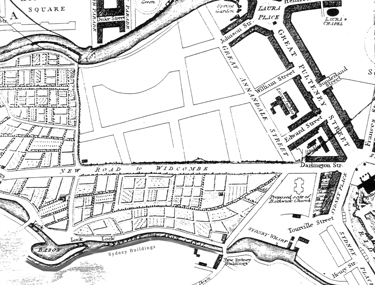
Map of 1810
Click on the image to see an enlarged section
By 1840 the Tithe map shows the ownership of plots extending on the west side beyond the last Georgian house.
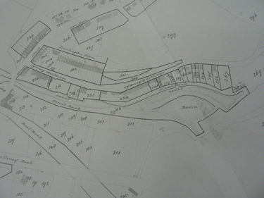
Tithe map of 1840
Click on the image to see the map enlarged
As well as dwellings, the early development was important in supplying wharves and storage yards for the building work. Later on in the century many of the temporary constructions were replaced by houses, and given names rather than numbers in the road.
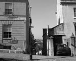
On the east side, Darlington Cottage is shown opposite numbers 6 and 7, and is still there today, an anomaly among the more formal Georgian and Victorian houses.
Darlington Cottage as it is today
Opposite the cut stood Bathwick Farm, listed in the Post Office Directories as a dairy from 1856 to 1876. The farm has been replaced by what is now 21 Darlington Place. Beyond this was, and still is, Smallcombe Farm and then Sydney Cottage, which would become Smallcombe Nurseries in the 1920s.
Smallcombe Cemetery, at the southern end of the road, was opened in 1856 and many former residents are buried there.
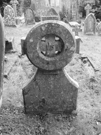
Smallcombe Cemetery
In 1902, in order to establish a sensible numbering system for the road, the houses were renumbered from 1 to 54. As there was still some free land available between existing houses, numbers 11, 43, 44 and 53 were not allocated. With the exception of 53, where a block of three flats was built in the late 1960s, the numbers are still not allocated today.
The 1903 Post Office Directory after the 1902 renumbering
Click on the image to see the page enlarged
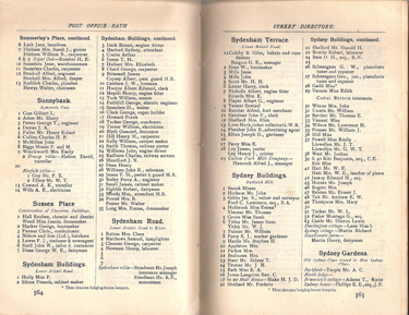
In 1932 permission was given to build 8 houses beyond No 54. These were built as separate dwellings, but the addition of garages and sheds mean that today many appear to be joined.
Building Plans for No 55 to 62
Sydney Buildings did not receive a direct hit during World War II but those years were hard on the buildings and their inhabitants. Many of the railings and window boxes disappeared into the war effort and several families were now living in what had been a one family home. The last house in the road, No 63, was built in 1979. The two remaining industrial buildings are still businesses, with an architectural practice and a Planning Consultancy at the Malt House, and another architectural practice in what was the Somerset Coalhouse, No 23a.
In recent times there has been considerable investment put into the conservation and maintenance of the buildings, by the owners, to make the road what it is today.
Up
Continue
Sydney Buildings History Group ©